Live Update Dashboard
There are no current live updates!
These are the previous 5 live updates:
From 2026-09-16
🔴 LIVE UPDATE at 8:35 AM:
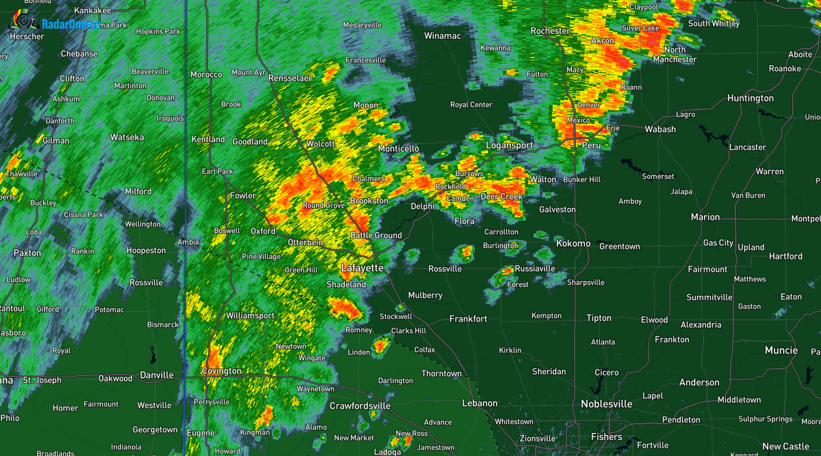
Currently there is scattered rain/thunderstorms throughout Indiana. More will develop later today according to the 11Z run of the HRRR model.
There is currently a Mesoscale Precipitation Discussion #1300 for some areas of Indiana and other states. The summary states that
Heavy rainfall is expected across portions of the Midwest into mid-morning. Hourly rain amounts to 2.5" with additional totals to 4" remain possible, which could lead to widely scattered flash flooding.
To see the full Mesoscale Precipitation Discussion #1300, please click
here.
If you want to see all of the active Mesoscale Precipitation Discussions, please go
here.
The average motion of the rain/thunderstorms is north-east. Stay safe.
At: 8:35 AM
From 2026-09-15
🔴 LIVE UPDATE at 7:28 PM:
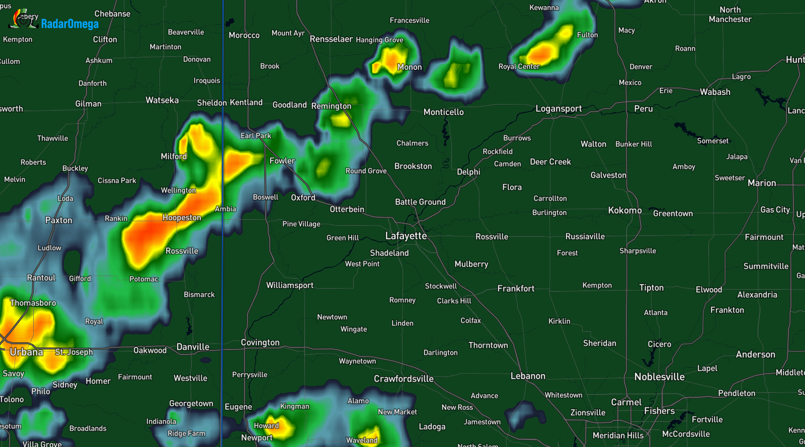
There is currently some rain/thunderstorms in Indiana and other states. They are moving north-east.
There are no severe thunderstorm warnings or special weather statements for the storms in the image above.
Radar Image from: Radar Omega.
At: 7:28 PM
From 2026-08-21
🔴 LIVE UPDATE at 7:11 PM:

A Severe Thunderstorm Watch has been issued for the following Indiana counties:
Lake, and Newton.
And for the following Illinois counties:
Boone, Bureau, Carroll, Cook, De Kalb, Dupage, Ford, Fulton, Grundy, Henry, Iroquois, Jo Daviess, Kane, Kankakee, Kendall, Knox, Lake, La Salle, Lee, Livingston, Mchenry, Mclean, Marshall, Mercer, Ogle, Peoria, Putnam, Rock Island, Stark, Stephenson, Tazewell, Whiteside, Will, Winnebago, And Woodford.
The severe thunderstorm watch also covers counties in Iowa and Wisconsin.
REMEMBER: A severe thunderstorm watch means the conditions are favorable for severe weather.
MAX WIND GUST: 70 MPH
MAX HAIL SIZE: 2 inches in diameter
At: 7:11 PM
From 2026-08-13
🔴 LIVE UPDATE at 3:15 PM:

A Severe Thunderstorm Watch has been issued for the following Indiana counties:
Benton, Boone, Clay, Clinton, Fountain, Hendricks, Montgomery, Owen, Parke, Putnam, Tippecanoe, Vermillion, Vigo, and Warren.
And for the following Illinois counties:
Champaign, Coles, Douglas, Edgar, Ford, Iroquois, Moultrie, Piatt, and Vermilion.
REMEMBER: A severe thunderstorm watch means the conditions are favorable for severe weather.
MAX WIND GUST: 75 MPH
MAX HAIL SIZE: 1 inch in diameter
At: 3:15 PM
From 2026-08-13
🔴 LIVE UPDATE at 5:53 PM:

🚨 IMPORTANT UPDATE: 🚨
The severe thunderstorm watch is now for the following Indiana counties:
Boone, Clay, Fountain, Greene, Hendricks, Monroe, Montgomery, Morgan, Owen, Parke, Putnam, Vermillion, and Vigo.
REMEMBER: A severe thunderstorm watch means the conditions are favorable for severe weather.
MAX WIND GUST: 70 MPH
MAX HAIL SIZE: 1 inch in diameter
At: 5:53 PM


