Click to view larger image.
Taken: 2026/06/10
The current/forecasted weather for each Pallsa Weather Member.
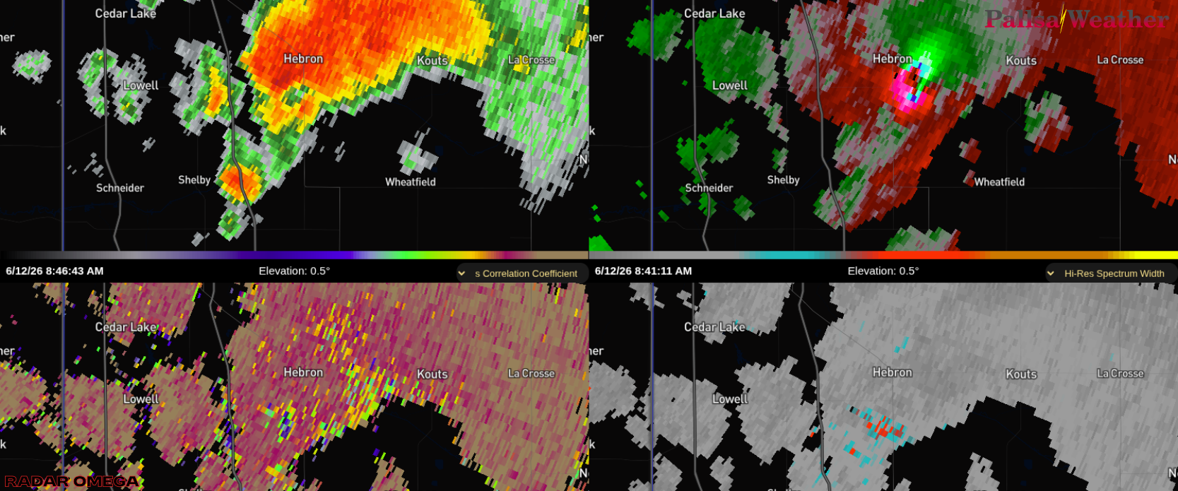
Hebron Tornado on Radar. Clockwise from topleft: Reflectivity, Velocity, Spectrum Width, Corelation Coefficient. Radar from Radar Omega.
📡🌪️ Above is a screenshot of the radar during the Hebron, Indiana tornado!! A Pallsa Weather Radar Analyst said that it was the best Corelation Coefficient (CC) drop they had ever seen!
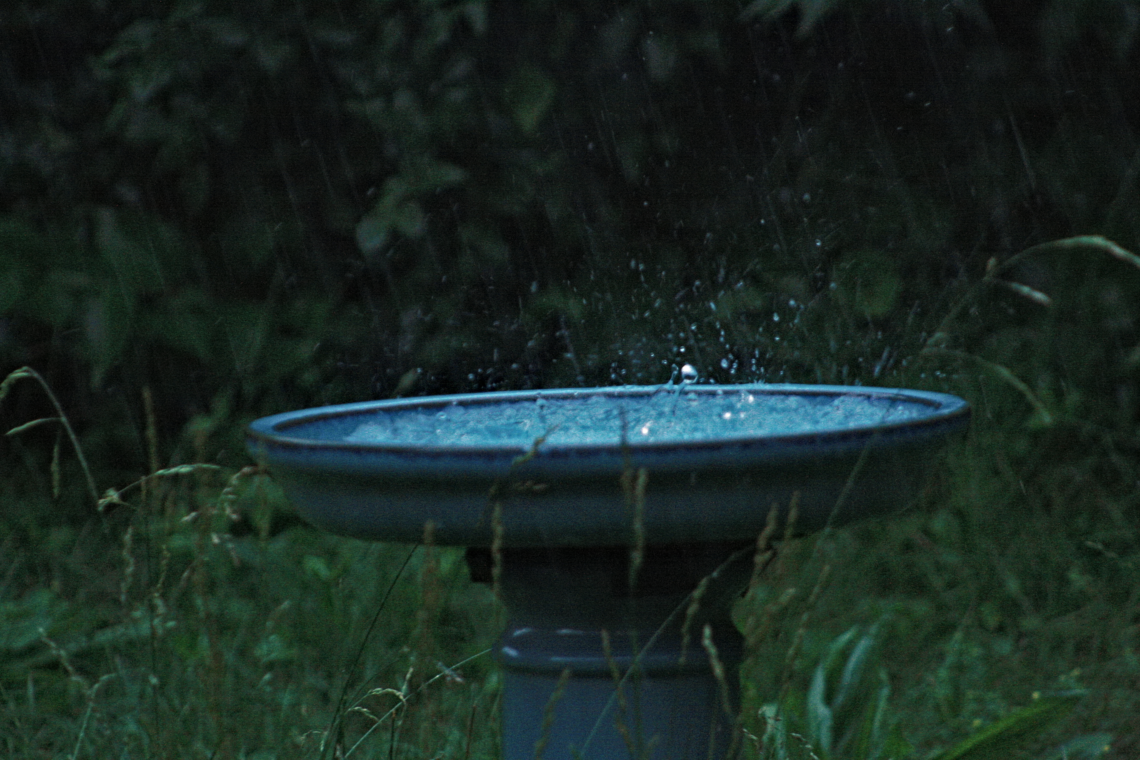
⛈️ Thursday, June 12th, 2026 was a crazy stormy day. There was one part of a line of storms that had more than four areas of rotation at one time!!! We hope everyone is safe. Multiple power outages were caused by these storms. It was a crazy night.
👍🏠 But today, make sure your ready for more storms to come. Check your drainage system(s)/gutters! Because storms are possible again Saturday!!! Next week also looks like another rainy/stormy week for some places!!!
🔔 Stay safe, dry, and alert!!!
📃 Forecast information from: National Weather Service. Radar from: Radar Omega.
2026-06-12
Updated:
💧 5%
Hi: 84℉
PM: Scattered Showers And Thunderstorms
💧 62%
Lo: 64℉
💧 49%
Hi: 74℉
PM: Partly Cloudy
💧 1%
Lo: 53℉
💧 1%
Hi: 74℉
PM: Partly Cloudy
💧 1%
Lo: 55℉
💧 38%
Hi: 76℉
PM: Chance Showers And Thunderstorms
💧 38%
Lo: 58℉
💧 58%
Hi: 77℉
PM: Showers And Thunderstorms
💧 86%
Lo: 65℉
💧 67%
Hi: 78℉
PM: Chance Showers And Thunderstorms
💧 30%
Lo: 59℉
💧 18%
Hi: 78℉
Currently only the next 36 hours.
Updated: 2026-06-13 At: 06:00 AM ET
Weather Information from: National Weather Service.
Updated:
💧 20%
Hi: 85℉
PM: Chance Showers And Thunderstorms then Showers And Thunderstorms
💧 89%
Lo: 62℉
💧 67%
Hi: 71℉
PM: Partly Cloudy
💧 0%
Lo: 50℉
💧 0%
Hi: 74℉
PM: Mostly Clear
💧 2%
Lo: 53℉
💧 62%
Hi: 76℉
PM: Showers And Thunderstorms Likely then Chance Showers And Thunderstorms
💧 62%
Lo: 55℉
💧 67%
Hi: 76℉
PM: Showers And Thunderstorms
💧 87%
Lo: 61℉
💧 54%
Hi: 75℉
PM: Slight Chance Showers And Thunderstorms then Partly Cloudy
💧 21%
Lo: 56℉
💧 9%
Hi: 77℉
Currently only the next 36 hours.
Updated: 2026-06-13 At: 06:00 AM ET
Weather Information from: National Weather Service.
Updated:
💧 16%
Hi: 86℉
PM: Chance Showers And Thunderstorms then Showers And Thunderstorms
💧 93%
Lo: 62℉
💧 64%
Hi: 68℉
PM: Partly Cloudy
💧 0%
Lo: 53℉
💧 0%
Hi: 75℉
PM: Partly Cloudy
💧 2%
Lo: 55℉
💧 60%
Hi: 77℉
PM: Showers And Thunderstorms Likely then Chance Showers And Thunderstorms
💧 60%
Lo: 57℉
💧 66%
Hi: 76℉
PM: Showers And Thunderstorms
💧 85%
Lo: 61℉
💧 54%
Hi: 75℉
PM: Slight Chance Showers And Thunderstorms then Partly Cloudy
💧 18%
Lo: 58℉
💧 9%
Hi: 78℉
Currently only the next 36 hours.
Updated: 2026-06-13 At: 06:00 AM ET
Weather Information from: National Weather Service.
Updated:
💧 14%
Hi: 84℉
PM: Chance Showers And Thunderstorms
💧 73%
Lo: 64℉
💧 72%
Hi: 72℉
PM: Partly Cloudy
💧 0%
Lo: 52℉
💧 1%
Hi: 73℉
PM: Partly Cloudy
💧 1%
Lo: 54℉
💧 42%
Hi: 76℉
PM: Chance Showers And Thunderstorms
💧 42%
Lo: 57℉
💧 64%
Hi: 77℉
PM: Showers And Thunderstorms
💧 88%
Lo: 64℉
💧 60%
Hi: 77℉
PM: Chance Showers And Thunderstorms
💧 26%
Lo: 58℉
💧 18%
Hi: 78℉
Currently only the next 36 hours.
Updated: 2026-06-13 At: 06:00 AM ET
Weather Information from: National Weather Service.
Updated:
💧 10%
Hi: 87℉
PM: Chance Showers And Thunderstorms then Showers And Thunderstorms
💧 89%
Lo: 62℉
💧 56%
Hi: 71℉
PM: Partly Cloudy
💧 0%
Lo: 58℉
💧 0%
Hi: 79℉
PM: Partly Cloudy
💧 2%
Lo: 61℉
💧 54%
Hi: 81℉
PM: Chance Showers And Thunderstorms
💧 54%
Lo: 62℉
💧 67%
Hi: 79℉
PM: Showers And Thunderstorms
💧 83%
Lo: 65℉
💧 44%
Hi: 78℉
PM: Partly Cloudy
💧 12%
Lo: 63℉
💧 7%
Hi: 81℉
Currently only the next 36 hours.
Updated: 2026-06-13 At: 06:00 AM ET
Weather Information from: National Weather Service.
Updated:
💧 2%
Hi: 84℉
PM: Scattered Showers And Thunderstorms
💧 63%
Lo: 64℉
💧 51%
Hi: 74℉
PM: Partly Cloudy
💧 2%
Lo: 53℉
💧 1%
Hi: 75℉
PM: Partly Cloudy
💧 1%
Lo: 54℉
💧 48%
Hi: 76℉
PM: Chance Showers And Thunderstorms
💧 48%
Lo: 58℉
💧 59%
Hi: 77℉
PM: Showers And Thunderstorms
💧 88%
Lo: 65℉
💧 66%
Hi: 78℉
PM: Chance Showers And Thunderstorms
💧 29%
Lo: 58℉
💧 15%
Hi: 78℉
Currently only the next 36 hours.
Updated: 2026-06-13 At: 06:00 AM ET
Weather Information from: National Weather Service.
Updated:
💧 36%
Hi: 87℉
PM: Chance Showers And Thunderstorms then Showers And Thunderstorms
💧 89%
Lo: 69℉
💧 58%
Hi: 79℉
PM: Partly Cloudy
💧 1%
Lo: 57℉
💧 1%
Hi: 75℉
PM: Partly Cloudy
💧 1%
Lo: 56℉
💧 2%
Hi: 79℉
PM: Mostly Clear
💧 14%
Lo: 62℉
💧 14%
Hi: 84℉
PM: Chance Showers And Thunderstorms
💧 41%
Lo: 73℉
💧 58%
Hi: 86℉
PM: Showers And Thunderstorms Likely
💧 69%
Lo: 67℉
💧 68%
Hi: 82℉
Currently only the next 36 hours.
Updated: 2026-06-13 At: 06:00 AM ET
Weather Information from: National Weather Service.
Updated:
💧 1%
Hi: 83℉
PM: Chance Showers And Thunderstorms
💧 48%
Lo: 62℉
💧 49%
Hi: 70℉
PM: Mostly Clear
💧 0%
Lo: 52℉
💧 0%
Hi: 73℉
PM: Mostly Clear
💧 0%
Lo: 54℉
💧 61%
Hi: 76℉
PM: Showers And Thunderstorms Likely then Chance Showers And Thunderstorms
💧 61%
Lo: 56℉
💧 57%
Hi: 76℉
PM: Showers And Thunderstorms
💧 85%
Lo: 61℉
💧 68%
Hi: 75℉
PM: Chance Showers And Thunderstorms then Partly Cloudy
💧 26%
Lo: 56℉
💧 11%
Hi: 76℉
Currently only the next 36 hours.
Updated: 2026-06-13 At: 06:00 AM ET
Weather Information from: National Weather Service.
Updated:
💧 1%
Hi: 86℉
PM: Scattered Showers And Thunderstorms then Chance Showers And Thunderstorms
💧 68%
Lo: 67℉
💧 61%
Hi: 76℉
PM: Partly Cloudy
💧 1%
Lo: 57℉
💧 2%
Hi: 75℉
PM: Partly Cloudy
💧 2%
Lo: 57℉
💧 16%
Hi: 78℉
PM: Chance Showers And Thunderstorms
💧 44%
Lo: 60℉
💧 41%
Hi: 80℉
PM: Chance Showers And Thunderstorms then Showers And Thunderstorms
💧 81%
Lo: 68℉
💧 81%
Hi: 81℉
PM: Chance Showers And Thunderstorms
💧 36%
Lo: 62℉
💧 23%
Hi: 81℉
Currently only the next 36 hours.
Updated: 2026-06-13 At: 06:00 AM ET
Weather Information from: National Weather Service.
Updated:
💧 0%
Hi: 85℉
PM: Scattered Showers And Thunderstorms
💧 60%
Lo: 65℉
💧 52%
Hi: 73℉
PM: Partly Cloudy
💧 1%
Lo: 53℉
💧 1%
Hi: 74℉
PM: Mostly Clear
💧 1%
Lo: 55℉
💧 35%
Hi: 76℉
PM: Chance Showers And Thunderstorms
💧 39%
Lo: 58℉
💧 56%
Hi: 77℉
PM: Showers And Thunderstorms
💧 88%
Lo: 65℉
💧 75%
Hi: 78℉
PM: Chance Showers And Thunderstorms
💧 32%
Lo: 59℉
💧 15%
Hi: 78℉
Currently only the next 36 hours.
Updated: 2026-06-13 At: 06:00 AM ET
Weather Information from: National Weather Service.
The current/forecasted weather for each Pallsa Weather Member.
Hebron Tornado on Radar. Clockwise from topleft: Reflectivity, Velocity, Spectrum Width, Corelation Coefficient. Radar from Radar Omega.
📡🌪️ Above is a screenshot of the radar during the Hebron, Indiana tornado!! A Pallsa Weather Radar Analyst said that it was the best Corelation Coefficient (CC) drop they had ever seen!
⛈️ Thursday, June 12th, 2026 was a crazy stormy day. There was one part of a line of storms that had more than four areas of rotation at one time!!! We hope everyone is safe. Multiple power outages were caused by these storms. It was a crazy night.
👍🏠 But today, make sure your ready for more storms to come. Check your drainage system(s)/gutters! Because storms are possible again Saturday!!! Next week also looks like another rainy/stormy week for some places!!!
🔔 Stay safe, dry, and alert!!!
📃 Forecast information from: National Weather Service. Radar from: Radar Omega.
2026-06-12
Scroll to the left to view the days.
Updated:
💧 5%
Hi: 84℉
PM: Scattered Showers And Thunderstorms
💧 62%
Lo: 64℉
💧 49%
Hi: 74℉
PM: Partly Cloudy
💧 1%
Lo: 53℉
💧 1%
Hi: 74℉
PM: Partly Cloudy
💧 1%
Lo: 55℉
💧 38%
Hi: 76℉
PM: Chance Showers And Thunderstorms
💧 38%
Lo: 58℉
💧 58%
Hi: 77℉
PM: Showers And Thunderstorms
💧 86%
Lo: 65℉
💧 67%
Hi: 78℉
PM: Chance Showers And Thunderstorms
💧 30%
Lo: 59℉
💧 18%
Hi: 78℉
Currently only the next 36 hours.
Updated: 2026-06-13 At: 06:00 AM ET
Weather Information From: National Weather Service
Back to menu ↑
Scroll to the left to view the days.
Updated:
💧 20%
Hi: 85℉
PM: Chance Showers And Thunderstorms then Showers And Thunderstorms
💧 89%
Lo: 62℉
💧 67%
Hi: 71℉
PM: Partly Cloudy
💧 0%
Lo: 50℉
💧 0%
Hi: 74℉
PM: Mostly Clear
💧 2%
Lo: 53℉
💧 62%
Hi: 76℉
PM: Showers And Thunderstorms Likely then Chance Showers And Thunderstorms
💧 62%
Lo: 55℉
💧 67%
Hi: 76℉
PM: Showers And Thunderstorms
💧 87%
Lo: 61℉
💧 54%
Hi: 75℉
PM: Slight Chance Showers And Thunderstorms then Partly Cloudy
💧 21%
Lo: 56℉
💧 9%
Hi: 77℉
Currently only the next 36 hours.
Updated: 2026-06-13 At: 06:00 AM ET
Weather Information From: National Weather Service
Back to menu ↑
Scroll to the left to view the days.
Updated:
💧 16%
Hi: 86℉
PM: Chance Showers And Thunderstorms then Showers And Thunderstorms
💧 93%
Lo: 62℉
💧 64%
Hi: 68℉
PM: Partly Cloudy
💧 0%
Lo: 53℉
💧 0%
Hi: 75℉
PM: Partly Cloudy
💧 2%
Lo: 55℉
💧 60%
Hi: 77℉
PM: Showers And Thunderstorms Likely then Chance Showers And Thunderstorms
💧 60%
Lo: 57℉
💧 66%
Hi: 76℉
PM: Showers And Thunderstorms
💧 85%
Lo: 61℉
💧 54%
Hi: 75℉
PM: Slight Chance Showers And Thunderstorms then Partly Cloudy
💧 18%
Lo: 58℉
💧 9%
Hi: 78℉
Currently only the next 36 hours.
Updated: 2026-06-13 At: 06:00 AM ET
Weather Information From: National Weather Service
Back to menu ↑
Scroll to the left to view the days.
Updated:
💧 14%
Hi: 84℉
PM: Chance Showers And Thunderstorms
💧 73%
Lo: 64℉
💧 72%
Hi: 72℉
PM: Partly Cloudy
💧 0%
Lo: 52℉
💧 1%
Hi: 73℉
PM: Partly Cloudy
💧 1%
Lo: 54℉
💧 42%
Hi: 76℉
PM: Chance Showers And Thunderstorms
💧 42%
Lo: 57℉
💧 64%
Hi: 77℉
PM: Showers And Thunderstorms
💧 88%
Lo: 64℉
💧 60%
Hi: 77℉
PM: Chance Showers And Thunderstorms
💧 26%
Lo: 58℉
💧 18%
Hi: 78℉
Currently only the next 36 hours.
Updated: 2026-06-13 At: 06:00 AM ET
Weather Information From: National Weather Service
Back to menu ↑
Scroll to the left to view the days.
Updated:
💧 10%
Hi: 87℉
PM: Chance Showers And Thunderstorms then Showers And Thunderstorms
💧 89%
Lo: 62℉
💧 56%
Hi: 71℉
PM: Partly Cloudy
💧 0%
Lo: 58℉
💧 0%
Hi: 79℉
PM: Partly Cloudy
💧 2%
Lo: 61℉
💧 54%
Hi: 81℉
PM: Chance Showers And Thunderstorms
💧 54%
Lo: 62℉
💧 67%
Hi: 79℉
PM: Showers And Thunderstorms
💧 83%
Lo: 65℉
💧 44%
Hi: 78℉
PM: Partly Cloudy
💧 12%
Lo: 63℉
💧 7%
Hi: 81℉
Currently only the next 36 hours.
Updated: 2026-06-13 At: 06:00 AM ET
Weather Information From: National Weather Service
Back to menu ↑
Scroll to the left to view the days.
Updated:
💧 2%
Hi: 84℉
PM: Scattered Showers And Thunderstorms
💧 63%
Lo: 64℉
💧 51%
Hi: 74℉
PM: Partly Cloudy
💧 2%
Lo: 53℉
💧 1%
Hi: 75℉
PM: Partly Cloudy
💧 1%
Lo: 54℉
💧 48%
Hi: 76℉
PM: Chance Showers And Thunderstorms
💧 48%
Lo: 58℉
💧 59%
Hi: 77℉
PM: Showers And Thunderstorms
💧 88%
Lo: 65℉
💧 66%
Hi: 78℉
PM: Chance Showers And Thunderstorms
💧 29%
Lo: 58℉
💧 15%
Hi: 78℉
Currently only the next 36 hours.
Updated: 2026-06-13 At: 06:00 AM ET
Weather Information From: National Weather Service
Back to menu ↑
Scroll to the left to view the days.
Updated:
💧 36%
Hi: 87℉
PM: Chance Showers And Thunderstorms then Showers And Thunderstorms
💧 89%
Lo: 69℉
💧 58%
Hi: 79℉
PM: Partly Cloudy
💧 1%
Lo: 57℉
💧 1%
Hi: 75℉
PM: Partly Cloudy
💧 1%
Lo: 56℉
💧 2%
Hi: 79℉
PM: Mostly Clear
💧 14%
Lo: 62℉
💧 14%
Hi: 84℉
PM: Chance Showers And Thunderstorms
💧 41%
Lo: 73℉
💧 58%
Hi: 86℉
PM: Showers And Thunderstorms Likely
💧 69%
Lo: 67℉
💧 68%
Hi: 82℉
Currently only the next 36 hours.
Updated: 2026-06-13 At: 06:00 AM ET
Weather Information From: National Weather Service
Back to menu ↑
Scroll to the left to view the days.
Updated:
💧 1%
Hi: 83℉
PM: Chance Showers And Thunderstorms
💧 48%
Lo: 62℉
💧 49%
Hi: 70℉
PM: Mostly Clear
💧 0%
Lo: 52℉
💧 0%
Hi: 73℉
PM: Mostly Clear
💧 0%
Lo: 54℉
💧 61%
Hi: 76℉
PM: Showers And Thunderstorms Likely then Chance Showers And Thunderstorms
💧 61%
Lo: 56℉
💧 57%
Hi: 76℉
PM: Showers And Thunderstorms
💧 85%
Lo: 61℉
💧 68%
Hi: 75℉
PM: Chance Showers And Thunderstorms then Partly Cloudy
💧 26%
Lo: 56℉
💧 11%
Hi: 76℉
Currently only the next 36 hours.
Updated: 2026-06-13 At: 06:00 AM ET
Weather Information From: National Weather Service
Back to menu ↑
Scroll to the left to view the days.
Updated:
💧 1%
Hi: 86℉
PM: Scattered Showers And Thunderstorms then Chance Showers And Thunderstorms
💧 68%
Lo: 67℉
💧 61%
Hi: 76℉
PM: Partly Cloudy
💧 1%
Lo: 57℉
💧 2%
Hi: 75℉
PM: Partly Cloudy
💧 2%
Lo: 57℉
💧 16%
Hi: 78℉
PM: Chance Showers And Thunderstorms
💧 44%
Lo: 60℉
💧 41%
Hi: 80℉
PM: Chance Showers And Thunderstorms then Showers And Thunderstorms
💧 81%
Lo: 68℉
💧 81%
Hi: 81℉
PM: Chance Showers And Thunderstorms
💧 36%
Lo: 62℉
💧 23%
Hi: 81℉
Currently only the next 36 hours.
Updated: 2026-06-13 At: 06:00 AM ET
Weather Information From: National Weather Service
Back to menu ↑
Scroll to the left to view the days.
Updated:
💧 0%
Hi: 85℉
PM: Scattered Showers And Thunderstorms
💧 60%
Lo: 65℉
💧 52%
Hi: 73℉
PM: Partly Cloudy
💧 1%
Lo: 53℉
💧 1%
Hi: 74℉
PM: Mostly Clear
💧 1%
Lo: 55℉
💧 35%
Hi: 76℉
PM: Chance Showers And Thunderstorms
💧 39%
Lo: 58℉
💧 56%
Hi: 77℉
PM: Showers And Thunderstorms
💧 88%
Lo: 65℉
💧 75%
Hi: 78℉
PM: Chance Showers And Thunderstorms
💧 32%
Lo: 59℉
💧 15%
Hi: 78℉
Currently only the next 36 hours.
Updated: 2026-06-13 At: 06:00 AM ET
Weather Information From: National Weather Service
Back to menu ↑
